

Precipitation in future climates: rainstorms
/This project is aimed at characterizing changes in future precipitation suggested by climate models, and using that information along with observations to produce data-driven simulations that can be used to evaluate impacts (e.g. changes in floods, water supply, and agricultural yields).
Climate models robustly predict a rise that global rainfall will rise under warmer climate conditions, and that rain events become more intense (because a warmer atmosphere holds more water vapor). The combination also requires some third adjustment: because the projected increase in rainstorm intensity (about 6% per degree C of warming) is greater than the projected total rise in precipitation (about 3%/degree), some other aspect of precipitation in the climate models must change to compensate. Either storms are initiated less frequently, or rain events are shorter in duration, or rainstorms are smaller in extent, or some combination of these effects. To date no study has determined how exactly precipitation characteristics change, in part because of the statistical challenge of representing precipitation, a complex, non-Gaussian process with strong spatiotemporal correlations.
We have developed a new approach to characterizing changes in precipitation in future climates that moves away from considering time series at individual locations, and instead uses image-processing algorithms to identifying individual rainstorm events and capture the evolution of storms in space-time space. The effort does require a very large volume of data: observations and model output at very high spatial resolution on time steps of a few hours or less. In this study, we use dynamically downscaled climate model output (CESM downscaled with WRF) at 12 km, 3 hourly resolution. We compare model output to real-world precipitation estimated from weather radar: the NCEP Stage IV data product at 4 km, 1 hourly resolution.
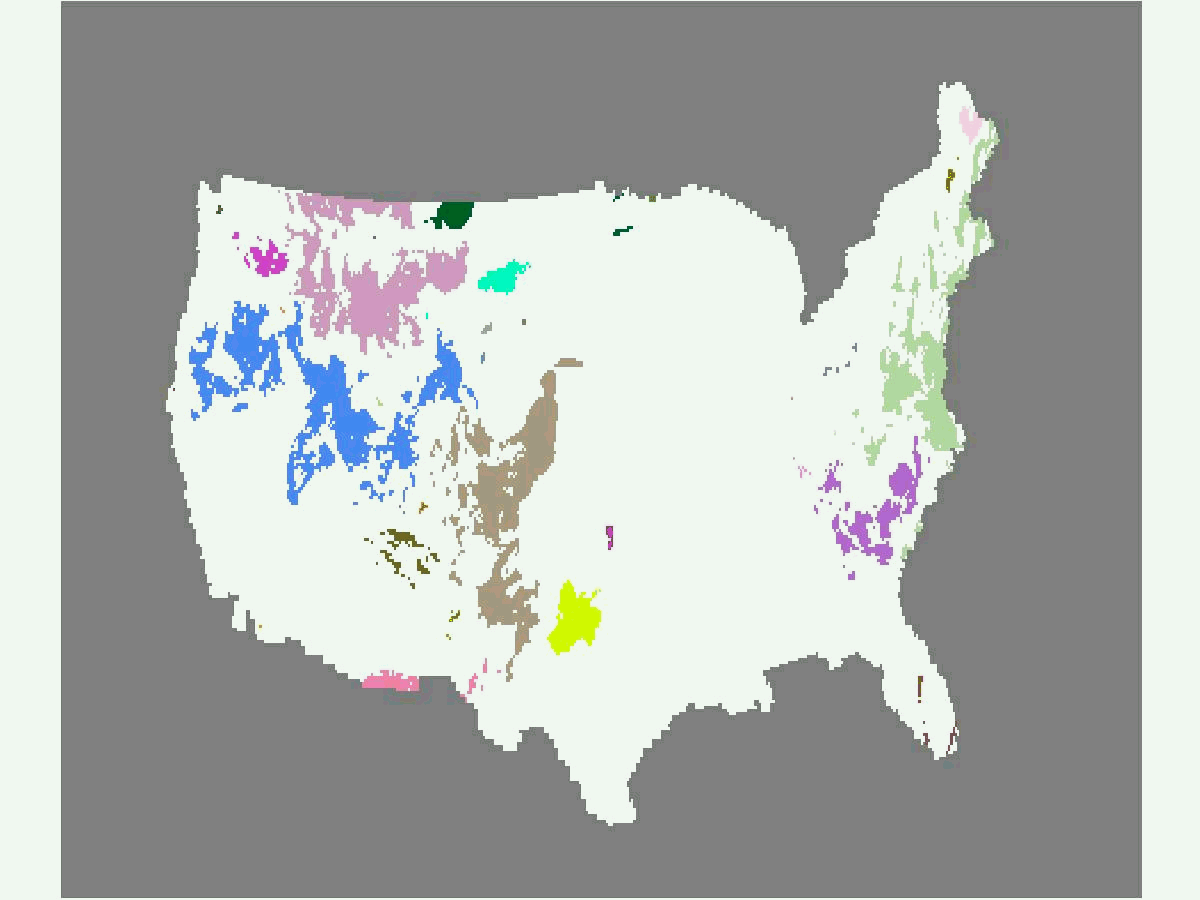

FIGURE 1: EXAMPLE OF RAINSTORM OBJECTS CONSTRUCTED BY OUR RAINSTORM IDENTIFICATION AND TRACKING ALGORITHM, FROM MODEL OUTPUT IN (LEFT) SUMMER AND (RIGHT) WINTER. COLORS REPRESENT DIFFERENT IDENTIFIED RAINSTORM OBJECTS. MOVEMENT OF SAME-COLORED REGIONS SHOW EVOLUTION OF INDIVIDUAL RAINSTORMS OVER TIME. IN SUMMER, CONVECTIVE STORMS INITIATE OVER MUCH OF THE U.S., ESPECIALLY IN THE WEST. RAINFALL IN WINTER OCCURS PRIMARILY IN LARGE-SCALE STORMS.
In the model output studied, we find that storms do indeed become more intense in future climate conditions but that their initiation, duration, and trajectories are nearly unchanged. The compensating adjustment is that storms simply become smaller in spatial extent.
The goal of this work is not only improving scientific understanding but developing statistical methods for generating future precipitation scenarios that combine information from both observational data and climate model runs. That is, simulations should capture the changes shown in models but preserve the statistical characteristics of real-world rainfall. Altering the spatial extent of rain events in data is non-trivial. Figure 2 below shows the application of a transformation algorithm applied to Stage IV radar data. In general, we hope this work will enable new ways of thinking about precipitation events in both meteorology and climatology.

Figure 2: Example OF precipitation patterns in observations (left) and after transforming the rainstorm size and intensity (RIGHT). Red crosses represent the intensity-weighted center of individual rainstorms. To simulate the rainstorm size changes suggested by our regional climate model runs, we shrink Or enlarge each rainstorm by reducing or increasing the distance to this center from individual rainstorm pixels. After resizing, we transform the rainfall intensity time series at each location to reflect the intensity distribution changes suggested by our model runs.
People
Won Chang | V. Rao Kotamarthi | Elisabeth Moyer | Michael Stein | Jiali Wang
Recent Presentations:
Won Chang. A conditional simulation approach to future precipitation scenario generation. Poster presented at: Data Assimilation Workshop, STATMOS Summer School. May 2015.
Won Chang. A conditional simulation approach to future precipitation scenario generation. Poster presented at: STATMOS Annual Meeting. University of Chicago, Chicago, IL. September 2014.